
NAVWAR – A Bad Idea for Too Many Reasons – A Future Catastrophe
Five years ago, many of us from throughout the city of San Diego and county, made a decision to not support the major development of the NAVWAR site, which is on Pacific Highway in Old Town. It literally backs up to the most western part off Old Town San Diego.
Though over 5,000 people from throughout the county of San Diego signed a petition in opposition of the major development proposed for the site, which includes high rises for hotels and some housing, it has recently become a subject of town hall meetings by various community groups, including the Peninsula Planning Group.
No surprise to the citizens of San Diego, City Hall has been backing a massive high-rise development for NAVWAR. This would gridlock coast traffic and create a huge visual obstruction of the bay and ocean views for residents near the site. It would also change the character of Old Town San Diego, the “birthplace of the State of California”. Ironically and for obvious reasons, Old Town San Diego State Park is the most frequented state park in the state of California that doesn’t receive fair funding though it brings in the most revenue annually to benefit the state park system.
Previously, Save Our Access, a 501c3 nonprofit, favored having the Navy renovate NAVWAR with creation of an area river trail park on part of this public land, which could be used by all San Diegans for recreational purposes.
The Navy’s Environmental Impact Statement (EIS) for the reuse of the 70.5 acres NAVWAR sites in the Midway district was presented.
The EIS’s “preferred alternative” was a NAVWAR high-rise commercial development consisting of 106 buildings stretched for half a mile along I-5 that reach up to 350-feet in the air. This plan included ten thousand new residential units for 14,000 residents.
Those of us who live in close proximity know that this proposal will overwhelm area roads and parks. EIS renderings at that time show views from Presidio Hills, Mission Hills, and Old Town will be totally blocked. The traffic impacts cannot be mitigated. These impacts would be felt by San Diegan’s throughout the county, not just by those living and working in close proximity of the site.
That’s because the high-rise wall of development would be the equivalent of a new city. It would bring decades of impacts like ongoing air pollution, construction noise, torn up streets, and major taxpayer expenses for the required infrastructure.
Encouragingly, for their part, the Navy seemed content to create its new needed facilities without any public land privatization. This could be accomplished using either Navy redevelopment alone or public-private partnership collaboration.
To upgrade its facilities, the Navy needs about 1 million square feet. At the time, the Navy says its old footprint can greatly downsize, leaving much of the inland of the two parcels for a river trail park. This proposal would take five years instead of the mass development alternatives that would take upwards of 30 years, and would preclude the decades of disastrous impacts from high-rise wall construction.
Think of that, 30 years of construction at this site that would impact those using Taylor Street, Pacific Highway, Rosecrans, Midway and other streets considered some of the highest traffic areas in the city of San Diego. I-5 would also be seriously impacted.
The NAVWAR site is irreplaceable and invaluable public land. The Navy’s EIS provides no public benefit analysis to see how San Diego citizens might directly benefit from this proposal. No mention is made how already gridlocked coast and beach access would become even worse.
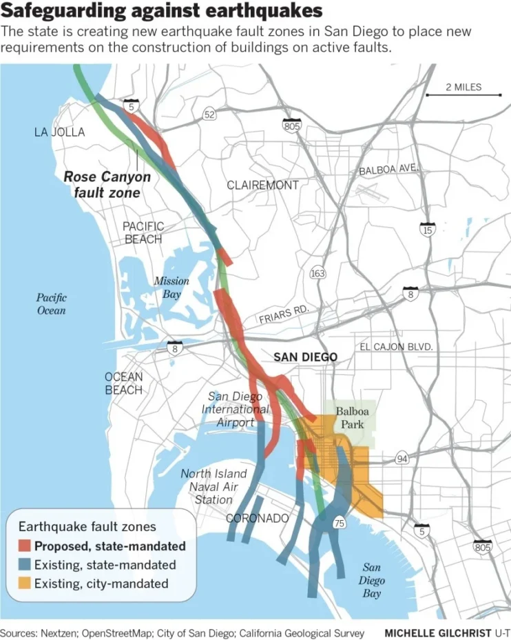
Add to all of this is the fact the soil right now, beneath this area, there’s a fracture in the Earth. It’s active and loaded with centuries of stored tectonic energy. And seismologists say it’s fully capable of producing a magnitude 6.9 earthquake, one that would fundamentally rewrite the geography of this city in under 20 seconds.
Most people who live here have never heard of it, and it’s not as famous as the San Andreas fault, but seismologists consider it one of the most dangerous urban faults in Southern California.
The Rose Canyon fault doesn’t appear on most maps, but it runs directly through the middle of one of the most densely populated cities on the West Coast. It comes ashore near La Jolla, tracks southeast through Rose Canyon, Mission Bay, under Old Town, and into San Diego Bay.
San Diego has a vulnerability most people have never heard of – artificial fill. Starting in the mid-century, the city dredged sand and sediment from the bay floor and pumped it onto wetlands and tidal flats. Mission Bay is the most dramatic example. A shallow estuary turned into 4,200 acres of parks and marinas. Dredged fill is not on bedrock.
Instead, it’s loosely packed sand and silt saturated with groundwater. Under normal conditions, it behaves like solid ground. But under seismic shaking, something completely different happens.
A gray slurry of water and sand spreads across the surface. Under normal conditions, sand and silt particles in dredged fill touch grain to grain, giving the material its loadbearing strength. Seismic waves cause those grains to lose contact. Water pressure between them increases until it exceeds the weight of material above. At that point, the entire mass, sand, silt, water behaves like a fluid.
Everything sitting on it sinks, tilts, or tears apart. Mission Bay is the most dramatic example, but not the only one. Parts of Mission Valley, Harbor Island, and downtown built on sediment fill experience similar effects. Apartment complexes experience differential settlement, causing doors to jam and walls to crack.
There is a reason many of these reclaimed estuarine sites remained relatively low intensity for decades. It was not necessarily because they were impossible to develop, but because they present substantially greater engineering complexity, higher construction costs, increased long-term risk, and significant infrastructure challenges.
What should concern us most is that the discussion should not be limited to whether individual buildings can be engineered to withstand a major earthquake. The larger question is whether the entire communities can continue to function well after a seismic event – economically included too.
Proposed projects such as Midway Rising and NAVWAR that plan on concentrating thousands of additional residents and visitors on liquefaction-prone reclaimed soils while relying upon an already constrained transportation network for everyday mobility and, more importantly, emergency response and evacuation following a major seismic event. When those geotechnical realities are combined with projected sea-level rise and the long-term vulnerability of critical infrastructure, the discussion becomes far broader than simply designing taller buildings. It becomes a question of community resiliency.
The larger and more consequential the project, the more important it becomes that geotechnical conditions, infrastructure capacity, emergency preparedness, and long-term resiliency are fully understood before decisions become permanent.
As a reminder, the Navy alone can renovate on site and free up part of the property to address the public’s need for recreation at a new River Trail Park – while possibly preventing catastrophic conditions that no one wants, nor can survive.
Category: feature, Government, Historical, Housing, Land issues, Local News